
Storage Layout#
Model Representation#
We map the physical space of the model domain bounded on top by topography (or a flat surface) into logical space that has uniform or variable resolution grids. Fig. 1 illustrates a model with three uniform resolution grids.
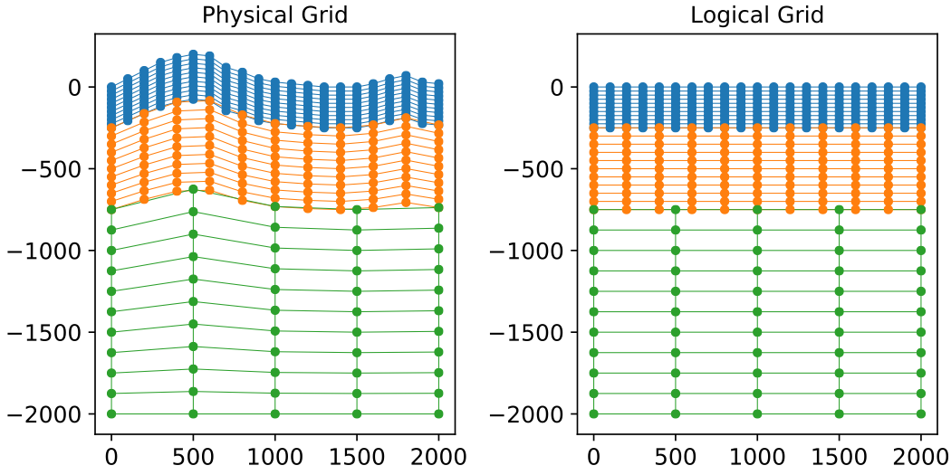
Fig. 1 Diagram showing a vertical slice through a model with three blocks, each of uniform resolution. The physical grid (left) represents the model in physical space and is warped to conform to topography. The logicl grid (right) represents the model in reference space and is used for fast, efficient queries of points.#
The mapping from the physical space to topological space is:
Data layout#
We use a Cartesian coordinate system (Fig. 2) for the model logical space with the origin at the top southwest corner (when the y axis is aligned with north) as shown in the figure.
We measure the rotation of the coordinate system for the model logical space using the azimuth of the y direction relative to north (y_azimuth in the diagram).
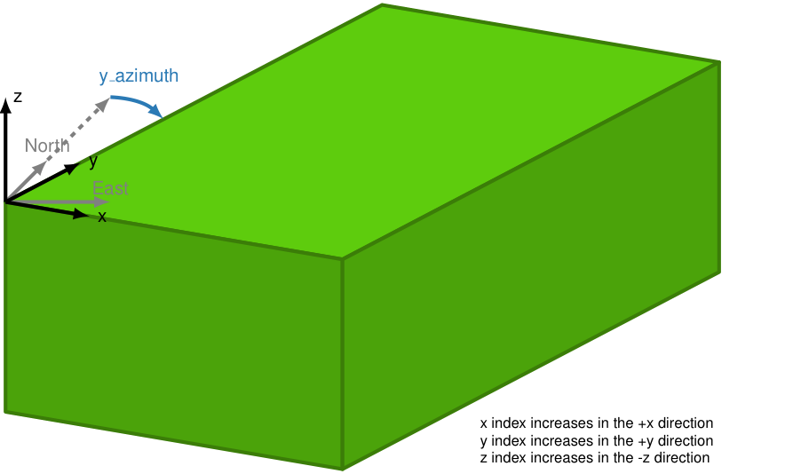
Fig. 2 Coordinate sytem for the logical grid with the origin in the top southwest corner. The logical grid may be rotated relative to the georeferenced coordinate system.#
For the logical space 4D arrays the x, y, and z indices are zero at the origin. The x index increases in the +x direction, the y index increases in the +y direction, and the z index increases in the -z direction.
HDF5 Storage Scheme#
The model is stored in an HDF5 file.
Fig. 3 shows a schematic of the data layout.
If the top surface of the model is not a flat surface at sea level, then a surfaces/top_surface dataset provides the elevation of the top surface.
Models may also include a surfaces/topography_bathymetry dataset to define topography and bathymetry, which corresponds to the top of the solid surface.
The grids are stored in the blocks group.
Attributes are included at the root level as well as for each dataset to yield a self-describing model.
That is, no additional metadata is needed to define the model.
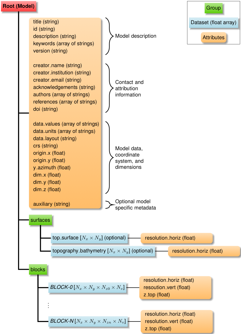
Fig. 3 Schematic of the HDF5 data layout for GeoModelGrids.
Model values are stored as uniform grids within the blocks group.
The elevation of surfaces are stored within the surfaces group.
Attributes are attached at the root level and each dataset to provide all metadata.
\(N_x\) is the number of points along the logical x axis.
\(N_y\) is the number of points along the logical y axis.
\(N_z\) is the number of points along the logical -z axis (downward).
\(N_v\) is the number of values at each point.#
Model Metadata#
Description#
title (string) Title of the model.
id (string) Model identifier.
description (string) Description of the model.
keywords (array of strings) Keywords describing the model.
creator_name (string) Name of person who created the HDF5 version of the model.
creator_institution (string) Institution/organization of model creator.
creator_email (string) Email of model creator.
acknowledgements (string) acknowledgements for the model.
authors (array of strings) Model authors.
references (array of strings) Publications describing the model.
doi (string) Digital Object Identifier for model.
version (string) Version of model.
auxiliary (string, optional) Auxiliary metadata in json format.
Model Data#
data_values (array of strings) Names of values in model grids.
data_units (array of strings) Units of values in model grids.
data_layout (string)
vertexfor vertex-based layout (values are specified at vertices) orcellfor cell-based layout (values are specified at centers of grid cells). Currently only vertex-based values are supported.
Model Storage#
crs (string) Coordinate reference system (CRS) in Proj.4 format, WKT, or EPSG code.
origin_x (float) X coordinate of origin of model in CRS coordinates.
origin_y (float) Y coordinate of origin of model in CRS coordinates.
y_azimuth (float) Azimuth (degrees clockwise from north) of y axis.
dim_x (float) Dimension of model in local (rotated) x direction in units of CRS coordinates.
dim_y (float) Dimension of model in local (rotated) y direction in units of CRS coordinates.
dim_z (float) Dimension of model in local z direction in units of CRS coordinates.
Surface Metadata#
resolution_horiz (float) Horizontal resolution in units of CRS coordinates.
Block Metadata#
resolution_horiz (float) Horizontal resolution in units of CRS coordinates.
resolution_vert (float) Vertical resolution in units of CRS coordinates.
z_top (float) Z coordinate of top of block in topological space.